
PDD Geoguessr #26: Duluth City Limits

Arriving in Duluth (Photo by Matthew James)
“Twenty-six miles long and an average of 2-1/2 miles wide, Duluth is squeezed between rocky bluffs and the waterfront of Lake Superior and the St. Louis River,” a National Geographic reporter wrote when describing the city in 1949. This post describes some of the stranger contours of our long and narrow city with a Geoguessr challenge at the end to test your knowledge of the city limits.
Duluth’s unusually narrow shape has a pretty clear origin story. The 1854 Treaty of La Pointe, in which representatives of the Ojibwe ceded land in the the Arrowhead Region of Northeastern Minnesota in exchange for reservations and retention of hunting, fishing and gathering rights, led to an influx of settlers to the area. Numerous small townships formed along the head of the lake and the shores of the St. Louis River. Duluth was not always the largest of these new settlements but it was the one that became the best at fusing with townships that previously had their own municipal government. This included Portland in 1870, Lakeside in 1893, West Duluth and Oneota in 1894, and New Duluth and Fond du Lac in 1895.
This process resulted in the city that we have today, a city whose angular borders form a rather remarkable shape. Local author Kathleen Murphy wrote in the Duluth News Tribune:
I see a mountainous skyline with an exploding volcano. The land that juts out from the area around the airport is the exploding lava, Minnesota Point the conduit where the magma travels upwards from deep within the ground. Several more peaks surround the volcano, while a river meanders past its base — like it was lifted right from the pages of a high school geography textbook.

The shape of Duluth (from the City of Duluth)
Within these jagged borders are a few peculiarities. One of the first episodes in the Northlandia podcast series explored how two small chunks of Wisconsin ended up on the Duluth side of the St. Louis River.

These Google satellite images show how to get to Wisconsin without crossing the St. Louis River
And Duluth belongs to the select group of jurisdictions that include an enclave, a territory entirely surrounded by another territory. In the case of Duluth, this involves Kilchis Meadow and two other areas within the St. Louis River just to the south. According to a 1983 UMD master’s thesis on sedimentation, the name Kilchis Meadow appears on a 1825 map as a piece of land jutting out into the St. Louis River while attached the shoreline of the Minnesota side. At some point, it detached. The Northlandia podcast describes the border between Minnesota and Wisconsin tracing a line that follows the deepest point of the St. Louis River. Kilchlis Meadow has long since crossed this line, but it seems that Duluth has retained its historical claim even as it starts to bump up against the banks on the Wisconsin side of the river.

The border around the Spirit Lake area
The Geoguessr challenge today looks at city borders that are likely to be more familiar: those with signs that mark the entrance to the city. These appear on many of the roads on the city limits, but not all, which makes sense. It would take four signs on Martin Road just to tell people going in each direction that they had entered and then left Duluth twice.

Entering and leaving and entering and leaving Duluth on Martin Road
The signs telling you that Duluth has a population of 86,265 appear on the busiest and most familiar approaches to the city, which is why this Geoguessr challenge is a no move challenge. You already know the answer is somewhere along the edge, you just have to choose which one.
Each round has a time limit of 5 minutes.
PDD Geoguessr Challenge #26: Duluth City Limits
How to Play Geoguessr
GeoGuessr can be played on a laptop or desktop and on Android or IoS mobile devices with the GeoGuessr app. Just click on the link that fits how you play. You can create an account to keep track of your scores and see how you compare to other players or just click on the link above to play as a guest without having to create an account or log in.
Every game consists of five locations based on a theme chosen by the game creator. You are shown a Streetview image stripped of all the informational labels that are normally overlayed onto the image. Unless the challenge specifically restricts it, you can move around and look for clues like street signs and business names to find out where you are. The image below shows a basic overview of the Geoguessr screen layout and controls.
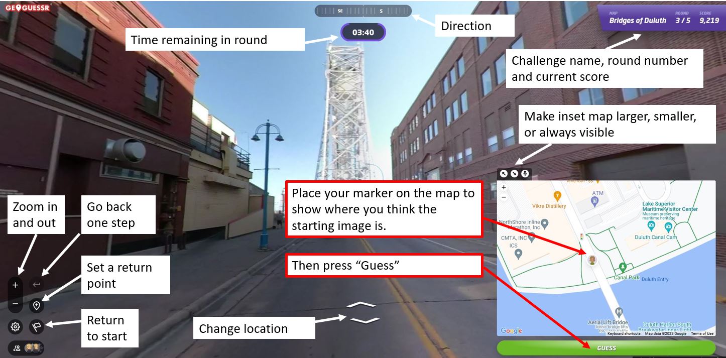
Once you think you know the location — or are nearly out of time — you use the inset map to place your marker where you believe the round started. After you hit “Guess,” you will see how close you were to the correct location and how many points your guess earned. The closer you are to the location, the higher your score, with a maximum score of 5,000 points. On a map that covers a small area, like the Gary-New Duluth neighborhood, being off by a few blocks will cost you a lot of points. On a map that has locations from around the world, you will get nearly all the points just for finding the right city. The maximum error for a perfect score also changes by map size, but in general if you are within 50 feet (15 meters) you will always get the full 5,000 points.
Not often, but every now and then, GeoGuessr gets a little buggy. If the underlying Streetview imagery has changed since the game was made, sometimes it repeats the last round, gives a black screen, or doesn’t allow a guess to be made. If that happens, please let me know and I’ll update the challenge.
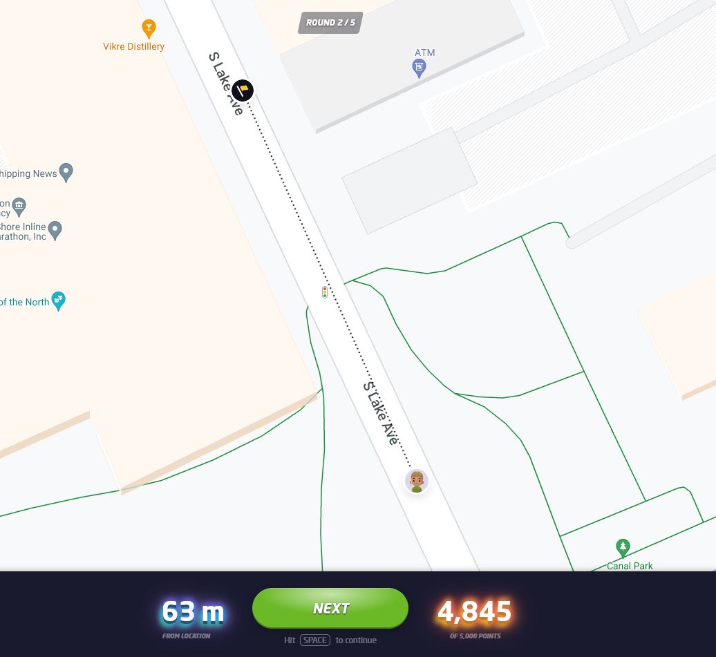
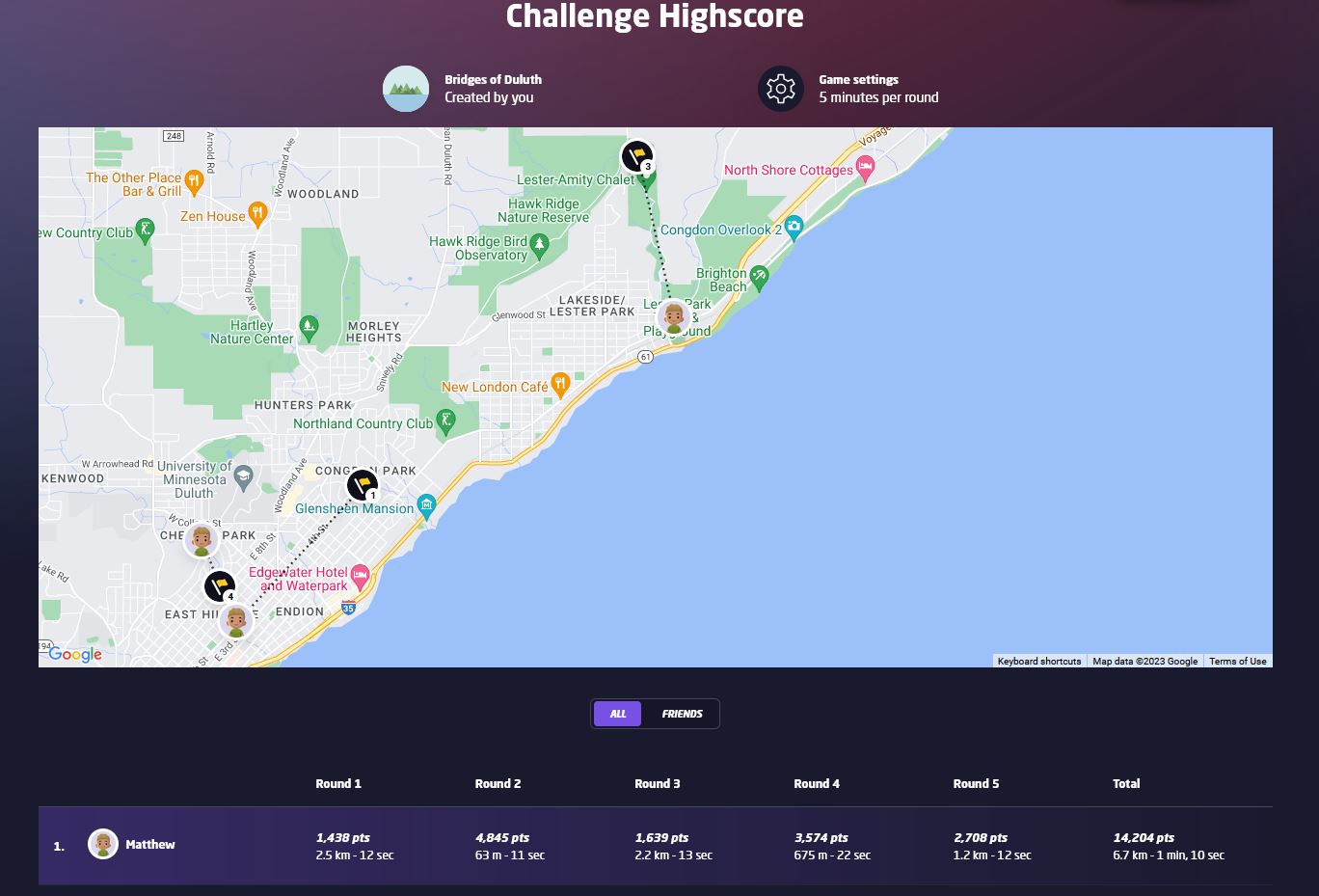
At the end of the five rounds, an overview screen shows your score for each round in addition to your guessing time and how far off you were from the correct location. The correct locations and your guesses are also shown on a map and you can click on any of the round numbers to review the locations. Additionally, the final screen in a challenge will show how you rank compared to the top scorers of the challenge. When choosing your user name, keep in mind that your user name and score per round will be visible to other players of the challenge.
If you have feedback on this challenge or ideas for future challenges, please share them in the comments below.


Leave a Comment
Only registered members can post a comment , Login / Register Here


No Comments