
PDD Geoguessr #24: Indigenous Land

A gas station on the Fond du Lac Reservation (Photo by Matthew James)
In 2019, the University of Minnesota Duluth became the first in the University of Minnesota system to adopt a land acknowledgment, a formal statement recognizing that UMD “is located on the traditional, ancestral, and contemporary lands of Indigenous people.” The land acknowledgement references the 1854 treaty in which representatives of the Anishinaabe ceded some of their land to settlement (while retaining certain rights on that land) and came to an agreement about which areas would be governed under tribal sovereignty. This Geoguessr challenge briefly examines the significance of the 1854 treaty and includes significant sites from reservations throughout Northern Minnesota.
As described by Linda LaGarde Grover in Onigamiising: Seasons of an Ojibwe Year, the term reservation comes from how the treaty process worked. During the treaty period, Indigenous tribes and U.S. government agencies negotiated the terms under which large tracts of land would be ceded to the United States. While there was enormous power imbalance in favor of the United States and the treaties came during a period of incredible destruction and loss for the indigenous people, the agreements are the outcome of a formal negotiation between two sovereign parties. This included negotiations on which land would be reserved for continued control by the indigenous people and ceded back to them at the conclusion of the negotiation process.
Minnesota has six reservations interconnected by a common governance system. White Earth, Leech Lake, Mille Lacs, Fond du Lac, Bois Forte and Grand Portage. In 1936, these six reservations, each the home of a federally recognized tribe, joined together and formed a constitution as the Minnesota Chippewa Tribe. The video below outlines the governance structures within the MCT.
In an article about the UMD land acknowledgement in the Pioneer Press, Jill Doerfler, the professor who heads the American Indian Studies department at UMD, explained a common misconception about the treaty that created the reservation system in Northern Minnesota:
The 1854 treaty is, in fact, the treaty that gives the rights for Americans to be here, so it’s super important for everyone to understand their rights … [These treaties] often are seen in dominant society as something that is about rights for American Indians. The treaties are, in fact American Indian nations giving rights to the U.S. It’s sort of the opposite of what most people have, a kind of false understanding of how treaties work.
The specific case of the Red Lake Nation illustrates this. While it has land in northern Minnesota, the Red Lake Nation is not part of the MCT because, as explained by Grover, it never ceded its land during treaty negotiations. The site Zaagibagaang: Anishinaabe Values in Action explains how the Red Lake Nation did not give up a number of rights during the treaty process and therefore operates differently from most tribes in the United States. For example, the tribe determine who can live on or access its land and it has its own constitution, with its legal system operating outside the jurisdiction of the Minnesota state courts.

A map showing Minnesota Chippewa Tribe land and other tribal lands in and around Minnesota. (graphic from Zaagibagaang)
This Geoguessr challenge’s consists of locations from northern Minnesota reservations that are of significance to the state’s indigenous communities both historically and in the present day. The rounds include Streetview imagery and Photospheres.
PDD Geoguessr #24: Indigenous land
How to Play Geoguessr
GeoGuessr can be played on a laptop or desktop and on Android or IoS mobile devices with the GeoGuessr app. Just click on the link that fits how you play. You can create an account to keep track of your scores and see how you compare to other players or just click on the link above to play as a guest without having to create an account or log in.
Every game consists of five locations based on a theme chosen by the game creator. You are shown a Streetview image stripped of all the informational labels that are normally overlayed onto the image. Unless the challenge specifically restricts it, you can move around and look for clues like street signs and business names to find out where you are. The image below shows a basic overview of the Geoguessr screen layout and controls.
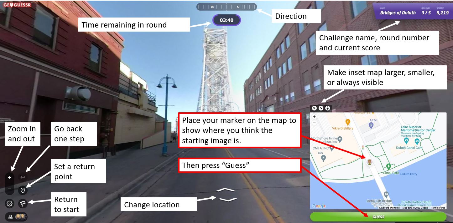
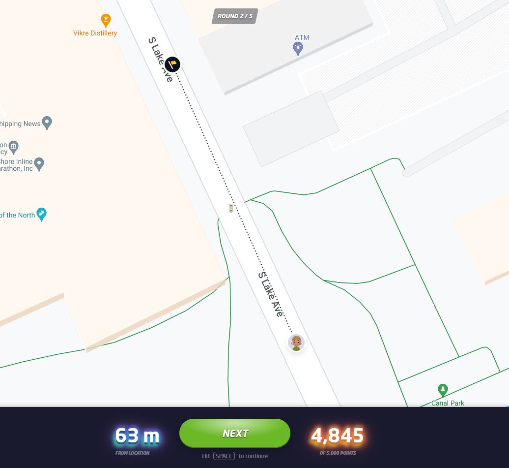
Once you think you know the location — or are nearly out of time — you use the inset map to place your marker where you believe the round started. After you hit “Guess,” you will see how close you were to the correct location and how many points your guess earned. The closer you are to the location, the higher your score, with a maximum score of 5,000 points. On a map that covers a small area, like the Gary-New Duluth neighborhood, being off by a few blocks will cost you a lot of points. On a map that has locations from around the world, you will get nearly all the points just for finding the right city. The maximum error for a perfect score also changes by map size, but in general if you are within 50 feet (15 meters) you will always get the full 5,000 points.
Not often, but every now and then, GeoGuessr gets a little buggy. If the underlying Streetview imagery has changed since the game was made, sometimes it repeats the last round, gives a black screen, or doesn’t allow a guess to be made. If that happens, please let me know and I’ll update the challenge.
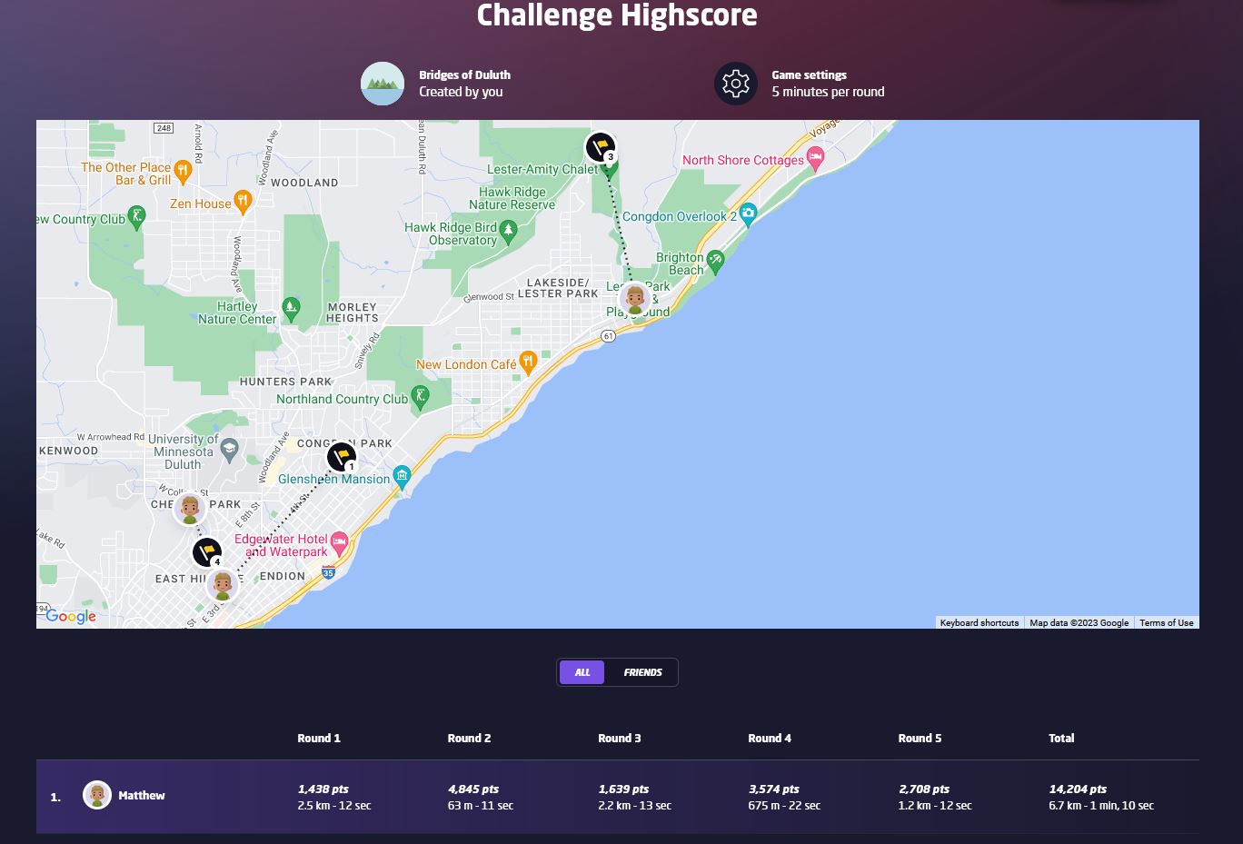
At the end of the five rounds, an overview screen shows your score for each round in addition to your guessing time and how far off you were from the correct location. The correct locations and your guesses are also shown on a map and you can click on any of the round numbers to review the locations. Additionally, the final screen in a challenge will show how you rank compared to the top scorers of the challenge. When choosing your user name, keep in mind that your user name and score per round will be visible to other players of the challenge.
If you have feedback on this challenge or ideas for future challenges, please share them in the comments below.


Leave a Comment
Only registered members can post a comment , Login / Register Here


No Comments