Mystery Photo: Duluth Home Builders

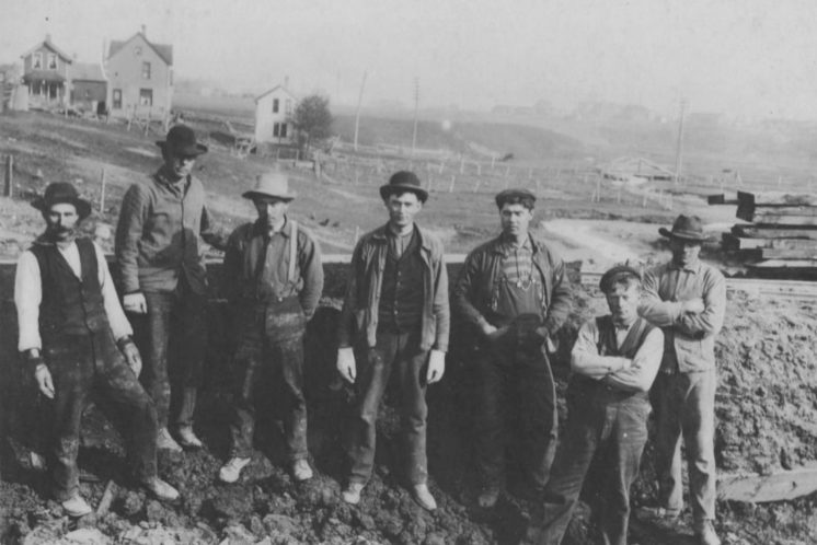
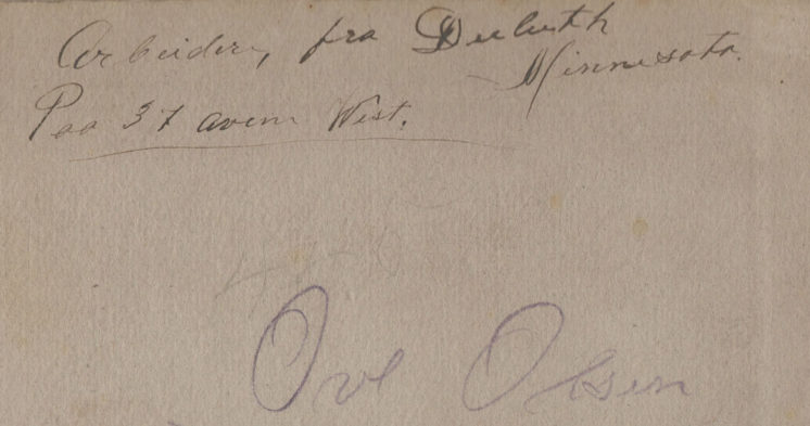
Who are they? Where are they? When was this? The only clues come from a few scribbles on the back of the photo.

There is a reference to 37th Avenue West, which leads to the notion that maybe the photo was shot in the vicinity of the ore docks and the Wheeler and Wade athletic complexes. There is also the name Ove Olsen.

11 Comments

Ghist1

about 2 years ago

I see the word "Arbeider" at the top, which sounded German to me but is more likely Norwegian for "worker." I looked up Ove Olsen and found surprisingly little on Ancestry; there is a 1912 City Directory entry for one, who was listed as "compositor" living on East Eighth Street. I had to look it up; apparently had to do with printing or typesetting.
  

Matthew James

about 2 years ago

Yes, the text seems to be "arbeidere fra Duluth, Minnesota på 37th ave west," which Google translate says is Norwegian for "Workers from Duluth, Minnesota on 37th ave west." Obviously that looks a lot more like "poo" than "på" but that's the only way I could make sense of the text.

Matthew James

about 2 years ago

37th Ave West seems like a particularly tricky location, even if the terrain does seem to give some clues, as the area seems to have changed considerably over the past 100 or so years. C.P. Frank's Atlas of the City of Duluth from 1902 shows housing plots divided up for a 37th Ave west (circled in red with two major current street circled in blue) but nothing actually built. If the houses in the background were built later, they may have been lost to highway development.
  

Matthew James

about 2 years ago

On a current map, the locations above would seem to correspond to what I've circled in red here.

Matthew James

about 2 years ago

While there never seemed to be an actual 37th Avenue West built in that north section near the Wheeler Athletic Complex, a 1939 aerial image shows that a group of houses used to stand just south of Wade Stadium on a street that, while at an angle to the other avenues, could plausibly have been designated as 37th Avenue West. This location seems to fit the details of the photo, as there is a rail line directly behind the workers with houses on the other side of the line. If the location circled in red is correct, they would all be looking north with this grouping of houses directly behind them.
  

Paul Lundgren

about 2 years ago


So if I'm following the theory here, the home builders in the photo are perhaps standing by the railroad tracks that are now a gravel trail on the edge of the Wade complex, and they are looking toward the hillside with the Hallett Dock and St. Louis River/Bay in the distance behind them. Google Maps can't come close to duplicating the perspective in the photo, but the broader map above might be more helpful in clarifying this anyway.

Or am I completely lost?

Chester Knob

about 2 years ago

Early DeLuth Residents of European Descent: "Let's cut down every single tree in all of DeLuth!"

Non-European Residents: "Um..."

Matthew James

about 2 years ago

Yes, Paul, you definitely understood where I was suggesting for the location and thanks for following up with the Google image. I like the location because it’s in the right general area and near a rail line of some sort. But I agree that the hills don’t seem to match at all and the development in the background, while quite fuzzy, doesn’t fit what you would expect if you were looking toward the water. 

I actually like this mystery photo quite a bit because for me it has gone from who are these people and where are these houses to ... what is 37th Avenue West? A seemingly simple and yet quite complicated question. And not just where it was, but to what degree it existed at all. 

The image below shows four different maps giving the location of 37th Avenue West. In the upper left is the present location, which is 37½ Avenue West. This present day fraction of an avenue doesn’t seem helpful at all for understanding the photo. 

In the upper right is a 1935 Duluth map that shows a significant portion of 37th Avenue West north of Grand Avenue. This doesn’t seem to align with historical aerial imagery or basic logic, as this portion of the avenue would have to have existed in Merritt Creek. 

The bottom left image comes from Aaron Isaac’s book Twin Ports by Trolley and shows 37th Avenue West listed as part of the streetcar line “West Duluth via Oneota.” The book also notes that a special spur line was constructed to go to the athletic park in this area, which might be the tracks seen in the mystery photo.

The bottom right shows a 1902 map where 37th Avenue West is plotted between Grand Avenue and Oneota Street, but not built. It provides a more detailed view of the complicated street network that existed before the construction of I-35.
  

Matthew James

about 2 years ago

I still think the location is likely to be somewhere in the upper left photo, amongst the residential buildings torn down for highway construction. You can see a few somewhat hilly areas that might match the topography of the photo, but even this photo from around 1950 is really too recent to understand what the neighborhood looked like when those houses were built. Streetcars no longer ran at that time and the Twin Ports by Trolley book notes that in 1940 Wade Stadium replaced an athletic stadium that had existed just to the south near 37th Avenue West. 

I did find two pictures related to 37th Avenue West. The upper right photo shows the Albert Olsen Grocery on the no longer existent Coates Street, near 37th Avenue West.

The lower right photo is a house at 3716 Coates near 37th Avenue West. So there definitely was a 37th Avenue West. Where those particular houses in the photo were in relation to it remains somewhat of a mystery to me. It does seem solvable though. Perhaps from finding a match for the topography in the photo or maybe even just having a proper translation of the Norwegian word “poo.”
  

hbh1

about 2 years ago

Your translation is correct. Before modern spellings, Norwegian "på" was spelled "paa." (And you'll see a lot of the old spellings in immigrant texts.)

Matthew James

about 2 years ago

Thanks, HBH1. In that hazy period between sleep and wakefulness this morning I had the realization that that one word might actually resolve a number of things. I’ve been trying to align the topology to find some location where those houses could plausibly be on 37th Avenue West, and have found some close matches for the houses, but for every house that looks like it could be right, some other element is clearly wrong. In all of this I’ve trusted that the labeling on the back of the photo is correct. 

But if that’s what I’m trusting, then I should trust it. It doesn’t say these workers are near 37th Avenue West. It says they are on 37th Avenue West. And they are working on constructing tracks, not building houses. So the maps and the writing above really have all the necessary information. According to the 1902 map, there are three places where tracks crossed the very short section of 37th Avenue West: the streetcar line and two freight tracks. And homes are visible in the distance, not water, so the general direction they are facing is also clear.  The streetcar line started operating in 1891 but those tracks are slightly elevated and there appears to be no street, so that suggests that the photo is from before 1891 and those are freight tracks, either running along 37th Avenue West or crossing it. The tracks crossing the avenue line up with the topography and the ones running along it do not. Therefore, I think it is most likely the location is the one shown below. The aerial image is from 1939, around 50 years after the photo was taken, which might explain the absence of the three key houses. Finding some evidence of those houses would be a nice way to confirm or reject this idea, but this seems much more plausible than the earlier location suggestion. In any event, it’s nice to see that the rail bridge over 37th Avenue West is still there, even if the rail is long gone.
  

Leave a Comment

Only registered members can post a comment , Login / Register Here