Duluth’s Point of Rocks

The main personality split in Duluth occurs about where an interfering spine of rocks comes down from the hill to Superior Street just a few blocks west of midtown. West of this point of rocks Duluth is politically left, east of it it is politically right. But there is a certain uniting force in cold weather, of which Duluth has its share.

–From “Duluth,” an essay by Arthur W. Baum
in the April 16, 1949, Saturday Evening Post

The Peerless Auto Body Fire post on PDD sparked some discussion of the former Peerless location near Point of Rocks, which led to some interest in the history of Point of Rocks.

So, here we go …

From Zenith: A Postcard Perspective of Historic Duluth, by Tony Dierckins:

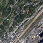
Since 1887 Duluthians have been chipping away at Point of Rocks, a giant rock outcropping near Thirteenth Avenue West and Superior Street.

Early attempts to remove the stone were spurred both by safety concerns and in order to make Superior Street straight. Shortly after the first blast in 1887, a huge boulder narrowly missed a man on horseback. In 1924 a movement grew to remove the natural landmark after 100,000 tons of rock fell onto Superior Street (another 100,000 tons fell in 1931 after heavy rains).

Duluthians found a use for the Point: both painted and handbill advertisements found their way onto the stone, as the postcards at left attest. In 1919, city leaders decided to turn Point of Rocks into a work of art. They brought in Mount Rushmore sculptor Gutzon Borglum to blast the rock into the form of the city’s namesake, Daniel Greysolon Sieur du Lhut. But Borglum found the stone too hard to carve and refused the job. (A bronze statue of du Lhut by famed sculptor Jacque Lipschitz stands in UMD’s Ordean Court.) Despite blasting and plans for public art, Point of Rocks remains-albeit smaller-and Superior Street still bows around it.

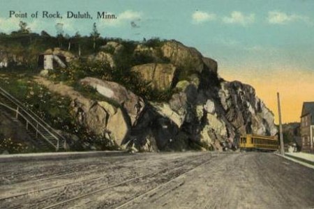
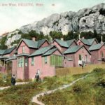
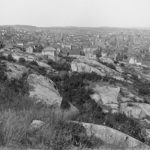
Here’s an old postcard view:

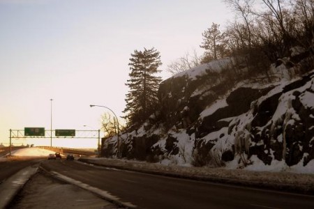
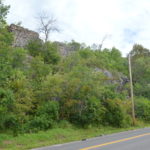
Below is a modern-day shot that includes (I’m pretty sure) the same rock. (It’s hard to tell, the area has been blasted so many times over the years.)

Here’s a story from the Feb. 15, 1902, Duluth News Tribune:

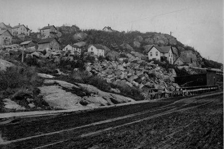
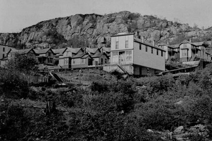
And here’s two photos from the X-Communication archives of the houses that made up the Little Italy neighborhood at Point of Rocks known as “The Glenn,” circa 1887.

Quoting Tony Dierckins:

Duluth’s Southern Italians, many of whom worked the railroad yards and coal docks, settled below Point of Rocks in an area also known as the Glenn. Prior to the Italians, this had been a French settlement. Most of the homes, built not along streets but on the hillside tucked within the rocks, were little more than shanties.

The ramshackle housing of the Glenn was dismantled and its streets were realigned. Ruins of foundations can still be found. The ruins of Duluth’s first water reservoir, which operated from 1883 to 1899, can still be seen rising from the hill above First Street between Tenth and Eleventh avenues west.

An article on street improvements in the Oct. 28, 1888 Duluth News Tribune notes:

Down by the point of rocks one may see the really colossal work. When a mountain gets in the way of a Duluth street it is hard on the mountain. The rock cut on West Michigan Street is well worth seeing, but the street that will result will be prettier to look at. They can no longer compare Duluth to a pair of saddlebags.

In the 1890s, Point of Rocks was mined for silver by the Duluth Silver and Copper Mining Co. They blasted a 300-foot tunnel into the rocks, spending $200,000 to extract $70,000 worth of silver.

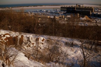
In the early 1900s, the city crushed rock there for building materials. Here’s a modern photo from the top of what clearly appears to be an old quarry.

In 1998, boulders fell from Point of Rocks onto the sidewalk at Mesaba Avenue. An excavation company was later brought in to ignite explosives and remove several giant chunks of rock deemed hazardous.

46 Comments

tom

about 14 years ago

I've been referring to it as "Whoopee Wall" since my UMD rock climbing days.  Perhaps it is only the climbers who call it this as it serves a quick "whoopee" climbing experience without driving out of town.

Paul Lundgren

about 14 years ago

Defining exactly what Point of Rocks is might be tricky, since there are several points, if one chooses to look at it that way. (I should also note that, although it's almost always referred to as Point of Rocks these days, older references render it in the singular -- Point of Rock.)

I believe Whoopee Wall is a section of Point of Rocks, although it is a bit west of the walls of rock in the images above. 

How or when Whoopee Wall got its name, I don't know, but it almost certainly comes from rock climbers who use it for its class-5 climbs.


Whoopee Wall is on Piedmont Avenue, between Superior and First streets.

rs

about 14 years ago

Sweet, thanks!!

Paul Lundgren

about 14 years ago

Here are four more postcard perspectives on Point of Rocks, Courtesy of X-communication, each one getting slightly nuttier as the circus apparently came to town in 1908.


I had a few drinks at Curly's Bar one night and thought I saw camels marching down Superior Street. I guess it wasn't the first time.

samh

about 14 years ago

There is a rich rock-climbing history in this area as has been slightly alluded to in the comments.  

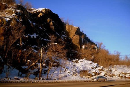
Point of Rocks is officially closed to climbing due to private property issues but contains one of the finest finger cracks within the city.  You can see the climb "Black Feather" represented in sunlit portion of the center of Paul's third photo above.  

Whopee Wall is easily confused with Point of Rocks by beginners because of it's close proximity.  It is open to climbing to all and contains a wealth of great climbs that are easily accessed for an afternoon after work.  Just watch out around base for broken glass and condoms!

Dave P

about 14 years ago

The name Whoopee Wall does indeed have its origins in the rock climbing community. It came about as the result of a bit of graffiti located on the large slab on the W. 1st Street side of the outcrop. The graffiti (pretty much weathered away at this point) said "Whope" and was assumed to be an attempt by a quasi-literate vandal to slander people of Italian descent. Climbers chose to pronounce it as Whoopee. The name has been a part of climbing vernacular since at least 1977-78.

Cory

about 14 years ago

I thought it was called Whopee Wall because it was a great place to make Whopee on top the wall. Which would explain the condoms at the bottom.  Huh? -- who knew?

Dave P

about 14 years ago

This is actually a terrible location to make Whoopee.

Paul Lundgren

about 14 years ago

A little wisecrack from the same Saturday Evening Post essay that this post begins with:

"Duluth has a terrible time with spelling; for example, Mesabi, Missabe, Mesaba, Mesabe."

Add to that Whoopee Wall, Whope Wall, Whopee Wall and Whoppie Wall.

And, of course, this reminds me of when we were "Speaking of the old Viking." 

Don't even get me started on Daniel de Gresolon or Greysolon, the Sieur Dulhut or Sir Duluth. That will have to be a whole new post.

Paul Lundgren

about 14 years ago

On June 15, 1897, a 2-year-old boy fell off Point of Rocks and fell an estimated 60 feet to the sidewalk below ... and survived.

The baby was the son of Mr. and Mrs. Edward Abrahamson, who lived at the 1300 block of West Third Street on a cliff overlooking Michigan Street.

The following day the Duluth News Tribune offered the horrific details:

He whirled over and over in his decent, striking on his head on the sidewalk. The child was thickly dressed and wore a cloak, which in the fall flew up about his head, and this probably afforded some slight protection.
The child was brought to "Dr. Tufte," who found "several indentations in the skull" but no "defined fracture." Yikes. Kids, remember to put on a thick cloak before playing near a cliff.

samh

about 14 years ago

Cloaks, and elephants, and condoms, oh my!

year of glad

about 14 years ago

The first picture looks like the rocks where W. Michigan meets Superior St. and Mesaba, and the first postcard looks the view going east on Superior Street (Minnesota Power would be on the right).

So are the rocks across from M&H and along Superior Street (going west) part of the point of rocks?

Paul Lundgren

about 14 years ago

Yes, the first photo is the eastern-most rocks of Point of Rocks. And yes, the postcard is the view going east on Superior Street around what I would consider the middle of Point of Rocks. (As mentioned before, I would consider Whoopee Wall the western edge of Point of Rocks).

I've never heard anyone debate the specific border of Point of Rocks -- so I guess whatever I say goes! -- but the rocks across from M&H are definitely part of Point of Rocks in anyone's book.

year of glad

about 14 years ago

Thanks, Paul. I was curious.

Paul Lundgren

about 14 years ago

Oct. 24, 1901:


Oct. 25, 1901:


In the opinion of A. M. Haskins, Point of Rocks was unsightly, dangerous and objectionable in 1907.

Spy1

about 14 years ago

Tee hee: He said "beetling crag."

Paul Lundgren

about 14 years ago

From May 10, 1910:

Paul Lundgren

about 14 years ago

1917 images of Point of Rocks from the Duluth Photo Engraving Co.:


From the Feb. 26, 1917, Duluth News Tribune:

Paul Lundgren

about 14 years ago

Apparently "Duluth's pocket" managed to shake some coins from "Uncle Sam's jeans" by selling rock from the infamous point.

This from a July 10, 1913 Duluth News Tribune article:


And a follow-up story from July 20, 1913:

Paul Lundgren

about 14 years ago

From April 30, 1918:

wildgoose

about 14 years ago

I don't know about rock climbing but my first thought when I heard "Whoopie Wall" was to ask Mrs. Goose if she wants to do a little sightseeing the first warm evening we get this summer *wink wink*  

Whatever it means, this is yet another Duluth term I had never heard before, but I like it.  However you spell it.  

Once again, Tony D's illumination helps me to understand things I often wondered about Duluth.  Like why the church near those rocks, St. Peter's, is (was) identified as so heavily Italian.  Those hardworking immigrants would have had quite a walk up the hill on their Sunday of rest.  I wonder if they stopped for a little "whoopie" on the way back down.

SlapShot

about 14 years ago

What would the local environmental crusaders have done if they tried to remove the Point of Rocks these days?

*shudders*

Paul Lundgren

about 14 years ago

They would point to what a bad idea it turned out to be 100 years ago, maybe shudder a bit, and then note that with I-35 in place there's even less reason to blast a road through.

Paul Lundgren

about 14 years ago

Duluth News Tribune opinion from Aug. 2, 1912:

Claire

about 14 years ago

So it's called "Point of Rocks" NOT "Point of the Rocks?"

Bad Cat!

about 14 years ago

I love how a stone outcropping is considered "wasteful government." I might believe that if it was commissioned and built, rather than placed there thousands of years ago by glaciers.

Rick Aylsworth

about 14 years ago

As a former Duluth resident and rock climber, I'd like to state that many of us in the climbing community are confident that the "Whope" graffiti was intended to read "Whore." But Whope is a little more palatable.

Racist Heir

about 14 years ago

My grandfather called it "Wop Hill."

He wasn't referring to Making Whoopee.

Paul Lundgren

about 13 years ago

I'm not including the full text of this article from Aug. 6, 1916, because it's difficult to read and the headline pretty much tells the whole story.

Paul Lundgren

about 13 years ago

Here's a fuzzy 1917 photo of a rock crusher from Point of Rocks.


The Duluth News Tribune caption reads: "Commissioner Farrell plans to remove the city rock crusher from the Point of Rocks, where it has been in use for several years, to another part of the city. The crusher, it is understood, will be replaced shortly by one with a larger capacity."

David

about 13 years ago

Paul, are you writing the first draft of a history book about Duluth on PDD?  Or do you just live in the local history room at the library downtown?

Paul Lundgren

about 13 years ago

I've been considering writing a local history book for many years, but I have no focused topic or financial incentive to complete such a project if I did have a focus, so the outlet for the hobby will probably always be PDD. 

I think there are a lot more people interested in snippets of history on the Internet than long, definitive books on a specific topic anyway. I mean, really, would you buy a book about Point of Rocks? Neither would I. I'd probably check it out of the library, but 99 percent of Duluthians wouldn't even do that.

I do occasionally go to the library to research stuff, including parts of this post, but all the newspaper clippings have been spoon fed to me from PDD's Fairy Research Spy. There are many more to come. And, as cited above, Tony Dierckins kicked in with a lot of info.

Paul Lundgren

about 13 years ago

In 1917, Victor Dash had an interesting suggestion.

adam

about 13 years ago

What, were people just allowed to make up their own awesome names in early Duluth?

Paul Lundgren

about 13 years ago

It should also be noted that the Darling Observatory was once on Point of Rocks.


This was the subject of a post on PDD back in 2007 in which V-Nick asked for info and a better photo. Mission finally accomplished. 

Here's a Duluth News Tribune article from Sept. 14, 1919 about the observatory.


Darling died in 1942. The city turned the observatory over to UMD, which operated it into the 1960s. It was torn down in 1972.

Below is a photo of Mr. Darling and his telescope from the Nov. 1930 issue of Popular Astronomy. 


The telescope is now in the lobby of the Marshall W. Alworth Planetarium at UMD. There is more info about it on UMD's website. 

Paul Lundgren

about 13 years ago

Ol' John Fredin had his share of trouble with the rocks in 1913.

Paul Lundgren

about 13 years ago

Here's a 1913 panorama from Point of Rocks.


(Click to see it larger.)

Paul Lundgren

about 13 years ago

Here's a story on plans to blast a 100-foot strip of Point of Rocks to widen Michigan Street in 1918:


Paul Lundgren

about 12 years ago

Here's a brand-new Lake Voice news piece about Point of Rocks, with commentary by yours truly and the esteemed Mr. Jim Heffernan.

Point of Rocks is Duluth's 'urban wilderness'

wildgoose

about 12 years ago

There is an awesome quote referring to Paul Lundgren as "president" of PDD.  Herewith, I think you need to update your PDD name to reflect that honorific.

wildgoose

about 12 years ago

Now, my more serious critique:

I give the article many points for some great quotes and for uncovering that detail about Gutzon Borglund.  What a nightmare it would have been if he had tried to fashion those rocks into one of his unearthly sculptures, especially of a white European!

The author is missing probably the most important historical detail about the Point of Rocks.  As I argued in another  post  about a year ago, the Point of Rocks appears to have been a major geographic landmark in what was Anishinaabe Chief Buffalo's claim in Duluth.  Chief Buffalo was a great American leader(yes, I said American, not just Native American leader). He made difficult decisions, suffered grave indignities, and made enormous sacrifices that led to a major surrender of land to the United States, but that also ensured a modicum of peace in this land which had been torn asunder by very much bloodshed in the mid-19th century.  The Ojibwe people are the second largest American Indian ethnic group in the United States today, I would argue that that would probably not have been the case had their been a US-Ojibwe War.  I could also argue that a weakened United States fighting wars on two fronts may very well have led to a victory for the Confederacy in the Civil War.  I'm not saying that these things are for-sure-true, I'm saying that I could make arguments for them.  For his leadership and sacrifices, Bizhiki was rewarded with a claim in the center of Duluth that was soon lost after his death, either by bad judgement or by swindle depending on who you talk to. That plot of land included the Point of Rocks which was a place that people could use as a safe harbor in case one of The Lake's nasty storms blew in unexpectedly. This history remains important and that is a story that needs to be told.

Paul Lundgren

about 12 years ago


A nice photo from 1905, with the rugged Point of Rocks in the background of downtown buildings.

Kathie

about 7 years ago

I realize it's years after the fact, but I just now stumbled on the whole discussion about the "Whoopee Wall" and wanted to clear up some misconceptions. 

First, no, the word "Whope" that was spray painted on the rocks was not meant as a slur toward the Italians that lived in the Glenn. It's actually a memorial to a young man named Joe Becker. Joey had just recently returned from a tour in Vietnam and after being home a while, joined a bike club called BPMs. Joey and some friends were drinking on First Street one night and, when the group was leaving the bar, for some reason a squad car decided to follow Joey. No one knows why, but it seems like Joey was going to try and outrun them. He almost made it, too, but near the Piedmont intersection he lost control of his bike, went over that cliff and crashed at the bottom. He was killed instantly. 

After his funeral, one of his friends, who was obviously lacking in spelling skills, went to mark the place where Joey died and spray painted "Whope" on the rocks. Joey's nickname had been Wop. 

This happened in 1973 or thereabouts. I'm old, my memory for dates isn't that great but, I remember the incident vividly because Joey was a good friend and a really nice guy. It always seemed so sad to me that Joey survived Vietnam, just to come home and die on First Street.

Leave a Comment

Only registered members can post a comment , Login / Register Here